By Akerele Christabel
Video shows buildings and vehicles covered in ice
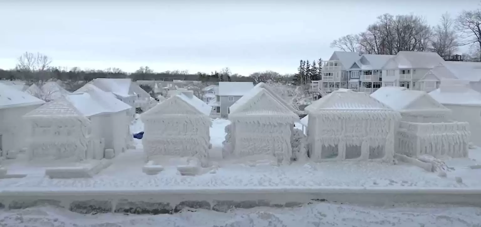
Video and photographs show buildings in upstate New York on the edge of Lake Erie entirely coated in ice, including monstrous-looking icicles spanning several feet long. Anyone walking through the streets will most probably feel like he stepped into a scene from an ice apocalypse.
One drone video flying through the Buffalo suburb of Hamburg begins shows a shot of the town clock tower buried in snow following the Christmas storm dubbed “the blizzard of the century” by Governor Kathy Hochul.
However, when the camera pans around the shores of Lake Erie, it rapidly cuts to almost apocalyptic sights of buildings coated in creepy-looking enormous icicles that totally obscure any windows, doors, or balconies.
“Those houses look like they’re from ‘The Day After Tomorrow,” a social media user commented on social media, referring to the 2004 disaster film.
Only the buildings on the water’s edge appear to be encased in the furious blizzard, but those farther behind them appear to be unaffected.
“I’d say it started on Friday, probably about eight or nine a.m.,” said restaurant owner Kevin Hoak, standing outside his icicle-covered eatery while interviewed by the NY Post.
He explained that high storm winds blew lake water over the structures, which swiftly turned to ice as the “bomb apocalypse” dropped temperatures from “45 degrees to roughly 12 degrees.”
On the brighter side, Hoak claimed that the unusual weather covering not only did not affect his business, but also protected it.
“It really protected the restaurant by going so low in temperature because it acts as a barrier, protecting the restaurant foundation,” Hoak added “with only the parking lot getting “very badly battered up.
It comes as the death toll in the Erie area has reached 36, according to CNN news, making it deadlier than the epic Blizzard of 1977, which killed up to 29 people.
The blizzard of 1977 swept through the regions for Western New York and Southern Ontario from January 28 to February 1. The National Weather Service recorded wind gusts ranging from 75-114 kilometers per hour and as high as 40 feet. With vehicles buried several feet beneath the ice, snowmobiles became the only viable means of transportation.
County Executive Mark Poloncarz of Erie County has labeled it “the worst storm certainly in our lifetime,” even for a region notorious for significant snowfall.
Mr Poloncarz stated that less than 1,000 houses in Erie County are currently without electricity, and that 95% of homeowners should have power restored by the end of the day.
According to county officials, the city of Buffalo, which got hit with more than four feet (1.2m) of snow, has made headway in cleaning roadways. According to Mr Poloncarz, at least 65% of city roadways have at least one passing lane, however a driving prohibition remains in effect owing to dangerous conditions.
After closing last Friday, the local Buffalo Niagara International Airport reopened at 11:00 a.m. local time (16:00 GMT), though nearly all scheduled departure flights for the day were cancelled or delayed, according to the airport’s website.
Buffalo’s rail service has resumed operations on a limited basis.
The US National Guard is going door-to-door in areas of the county that lost power to do health checks because officials are “fearful” that some people living alone died during the storm, according to Mr Poloncarz.
With temperatures rising and snow melting, the county is preparing for flooding, according to the county executive.
Residents in the United States and Canada are still dealing with the aftermath of the terrible winter storm, as well as other dangerous weather systems that have claimed countless lives.
As a result of a “atmospheric river,” a long narrow channel of moisture in the sky that can cause significant precipitation, states in the western United States and the Rocky Mountains region have seen high winds and rain.
According to the Weather Prediction Center, a rush of heavy rain or mountain snow is likely to hit the west and south of the United States on Thursday and might last through the end of the week.
Forecasts from the National Weather Service warned that winds over Lake Erie would climb to 60 mph and waves could grow to more than 25 feet during the peak of the storm last Friday and Saturday. Forecasters cautioned that “heavy freezing spray” could accumulate on surfaces at nearly an inch per hour.
The system began flooding the western states of Washington and Oregon on Tuesday, killing five people in car accidents caused by downed trees from the storm, according to Oregon State Police.
According to Oregon State Police, a big tree fell onto the roof of a car on Highway 26 in Clatsop County on Tuesday, killing the 19-year-old driver Justin Nolasco Pedraza and two passengers – a four-year-old girl and 41-year-old Bonifacio Olvera Nolasco. All three were discovered deceased at the scene by first responders.
According to outage tracker PowerOutage.us, more than 70,000 customers in Washington and Oregon were without power as of Wednesday afternoon.
The storm is anticipated to “linger into the approaching weekend,” according to the Weather Prediction Center.
According to officials, the Washington state capital of Olympia had a record high tide of 18.4 feet (5.6 metres), bringing marine life into the city’s streets.
Heavy snow is also expected in the Sierra Nevada, Cascades, and Rockies as moist air pushes eastward, according to the Weather Prediction Center.
Meanwhile, some Canadians are still without power as a result of the storm, including over 19,000 consumers in the province of Quebec, according to public utility provider Hydro-Québec on Wednesday.
According to Hydro One, more than 10,000 customers in Ontario were still without power.


Cancel anytime


Using our website
You may use the The Middle Land website subject to the Terms and Conditions set out on this page. Visit this page regularly to check the latest Terms and Conditions. Access and use of this site constitutes your acceptance of the Terms and Conditions in-force at the time of use.
Intellectual property
Names, images and logos displayed on this site that identify The Middle Land are the intellectual property of New San Cai Inc. Copying any of this material is not permitted without prior written approval from the owner of the relevant intellectual property rights.
Requests for such approval should be directed to the competition committee.
Please provide details of your intended use of the relevant material and include your contact details including name, address, telephone number, fax number and email.
Linking policy
You do not have to ask permission to link directly to pages hosted on this website. However, we do not permit our pages to be loaded directly into frames on your website. Our pages must load into the user’s entire window.
The Middle Land is not responsible for the contents or reliability of any site to which it is hyperlinked and does not necessarily endorse the views expressed within them. Linking to or from this site should not be taken as endorsement of any kind. We cannot guarantee that these links will work all the time and have no control over the availability of the linked pages.
Submissions
All information, data, text, graphics or any other materials whatsoever uploaded or transmitted by you is your sole responsibility. This means that you are entirely responsible for all content you upload, post, email or otherwise transmit to the The Middle Land website.
Virus protection
We make every effort to check and test material at all stages of production. It is always recommended to run an anti-virus program on all material downloaded from the Internet. We cannot accept any responsibility for any loss, disruption or damage to your data or computer system, which may occur while using material derived from this website.
Disclaimer
The website is provided ‘as is’, without any representation or endorsement made, and without warranty of any kind whether express or implied.
Your use of any information or materials on this website is entirely at your own risk, for which we shall not be liable. It is your responsibility to ensure any products, services or information available through this website meet your specific requirements.
We do not warrant the operation of this site will be uninterrupted or error free, that defects will be corrected, or that this site or the server that makes it available are free of viruses or represent the full functionality, accuracy and reliability of the materials. In no event will we be liable for any loss or damage including, without limitation, loss of profits, indirect or consequential loss or damage, or any loss or damages whatsoever arising from the use, or loss of data, arising out of – or in connection with – the use of this website.
Last Updated: September 11, 2024
New San Cai Inc. (hereinafter “The Middle Land,” “we,” “us,” or “our”) owns and operates www.themiddleland.com, its affiliated websites and applications (our “Sites”), and provides related products, services, newsletters, and other offerings (together with the Sites, our “Services”) to art lovers and visitors around the world.
This Privacy Policy (the “Policy”) is intended to provide you with information on how we collect, use, and share your personal data. We process personal data from visitors of our Sites, users of our Services, readers or bloggers (collectively, “you” or “your”). Personal data is any information about you. This Policy also describes your choices regarding use, access, and correction of your personal information.
If after reading this Policy you have additional questions or would like further information, please email at middleland@protonmail.com.
PERSONAL DATA WE COLLECT AND HOW WE USE IT
We collect and process personal data only for lawful reasons, such as our legitimate business interests, your consent, or to fulfill our legal or contractual obligations.
Information You Provide to Us
Most of the information Join Talents collects is provided by you voluntarily while using our Services. We do not request highly sensitive data, such as health or medical information, racial or ethnic origin, political opinions, religious or philosophical beliefs, trade union membership, etc. and we ask that you refrain from sending us any such information.
Here are the types of personal data that you voluntarily provide to us:
As a registered users or customers, you may ask us to review or retrieve emails sent to your business. We will access these emails to provide these services for you.
We use the personal data you provide to us for the following business purposes:
Information Obtained from Third-Party Sources
We collect and publish biographical and other information about users, which we use to promote the articles and our bloggers who use our sites. If you provide personal information about others, or if others give us your information, we will only use that information for the specific reason for which it was provided.
Information We Collect by Automated Means
Log Files
The site uses your IP address to help diagnose server problems, and to administer our website. We use your IP addresses to analyze trends and gather broad demographic information for aggregate use.
Every time you access our Site, some data is temporarily stored and processed in a log file, such as your IP addresses, the browser types, the operating systems, the recalled page, or the date and time of the recall. This data is only evaluated for statistical purposes, such as to help us diagnose problems with our servers, to administer our sites, or to improve our Services.
Do Not Track
Your browser or device may include “Do Not Track” functionality. Our information collection and disclosure practices, and the choices that we provide to customers, will continue to operate as described in this Privacy Policy, whether or not a “Do Not Track” signal is received.
HOW WE SHARE YOUR INFORMATION
We may share your personal data with third parties only in the ways that are described in this Privacy Policy. We do not sell, rent, or lease your personal data to third parties, and We does not transfer your personal data to third parties for their direct marketing purposes.
We may share your personal data with third parties as follows:
There may be other instances where we share your personal data with third parties based on your consent.
HOW WE STORE AND SECURE YOUR INFORMATION
We retain your information for as long as your account is active or as needed to provide you Services. If you wish to cancel your account, please contact us middleland@protonmail.com. We will retain and use your personal data as necessary to comply with legal obligations, resolve disputes, and enforce our agreements.
All you and our data are stored in the server in the United States, we do not sales or transfer your personal data to the third party. All information you provide is stored on a secure server, and we generally accepted industry standards to protect the personal data we process both during transmission and once received.
YOUR RIGHTS/OPT OUT
You may correct, update, amend, delete/remove, or deactivate your account and personal data by making the change on your Blog on www.themiddleland.com or by emailing middleland@protonmail.com. We will respond to your request within a reasonable timeframe.
You may choose to stop receiving Join Talents newsletters or marketing emails at any time by following the unsubscribe instructions included in those communications, or you can email us at middleland@protonmail.com
LINKS TO OTHER WEBSITES
The Middle Land include links to other websites whose privacy practices may differ from that of ours. If you submit personal data to any of those sites, your information is governed by their privacy statements. We encourage you to carefully read the Privacy Policy of any website you visit.
NOTE TO PARENTS OR GUARDIANS
Our Services are not intended for use by children, and we do not knowingly or intentionally solicit data from or market to children under the age of 18. We reserve the right to delete the child’s information and the child’s registration on the Sites.
PRIVACY POLICY CHANGES
We may update this Privacy Policy to reflect changes to our personal data processing practices. If any material changes are made, we will notify you on the Sites prior to the change becoming effective. You are encouraged to periodically review this Policy.
HOW TO CONTACT US
If you have any questions about our Privacy Policy, please email middleland@protonmail.com
The Michelin brothers created the guide, which included information like maps, car mechanics listings, hotels and petrol stations across France to spur demand.
The guide began to award stars to fine dining restaurants in 1926.
At first, they offered just one star, the concept was expanded in 1931 to include one, two and three stars. One star establishments represent a “very good restaurant in its category”. Two honour “excellent cooking, worth a detour” and three reward “exceptional cuisine, worth a
Thank you for your participation,
please Log in or Sign up to Vote

123Sign in to your account